 While the physical map shows the natural features of a place such as mountains, waterbodies plains, etc. The political map displays territorial features such as cities, state, countries and their boundaries.
A map is a useful tool, which diagrammatically represents the natural or man-made features of an area of land or part thereof, on a flat surface, according to scale. The three main components of the map are distance, direction and symbol. These are of great help to the travellers and navigators, to get some knowledge of a place they are visiting. There are three types of maps which are a thematic map, political map and physical map.
In the given article you can find the differences between physical map and political map.
Content: Physical Map Vs Political Map
Comparison Chart
| Basis for Comparison | Physical Map | Political Map |
|---|---|---|
| Meaning | Physical map can be understood as a map used to indicate the forms of landscape and water bodies of an area. | Political map refers to a map that helps in representating the geographical boundaries, roads, and other similar features of an area. |
| Use | It is used to show geographical features. | It is used to show territorial borders. |
| Features | Raised or dipped | Flat |
| Colors used | Dull colors are used. | Bright colors are used. |
Definition of Physical Map
Physical map or otherwise called as relief maps are the one that shows the natural characteristics of a form of land and bodies of water that are found in a particular area. In finer terms, it is a visual representation of how our earth looks from space.
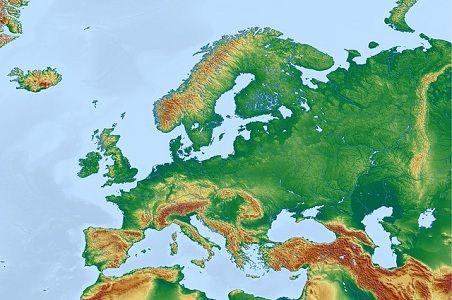 In this map, the water bodies like oceans, rivers, lakes and ponds are depicted in a blue colour. Likewise, brown colour indicates mountains and plateaus, different shades of green are used to represent elevations on a physical map. These maps help to understand, the range of elevation in the region, mountains or plateaus in the region, rivers in that region, direction in which the river flows and so forth.
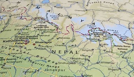
Definition of Political Map
Political Map is described as a map used by the travellers, tourists or other persons to locate various places, population, roads, highways, etc. of a particular area. The primary characteristic of political maps is that it shows administrative subdivisions of the world, or other geographical regions such as continents, countries, state, cities, towns and villages.
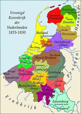 These maps use large water bodies like oceans, sea, rivers and lakes as landmark. There are three types of political maps, which are:
- General Maps
- Survey Maps
- Specialised Maps
Key Differences Between Physical and Political Map
The difference between physical and political map can be described here:
- The map that depicts the physical or natural characteristics of a landform, or a waterbody, along with its terrain and elevation it is called as a physical map. On the other hand, political map is a map used to show the geographical borders between villages, towns, state and countries.
- While physical map indicates geographical characteristics of an area, the political map illustrates the territorial characteristics.
- To depict features like mountains and valleys the features are raised or dipped in a physical map. As against this, the political map is flat.
- Usually, dull colours are used to show features in a physical map, whereas in a political map bright colours are used to differentiate between different cities, states and countries.
Conclusion
Maps are designed by the cartographers, who use different colours to highlight different features on a map. While the physical map shows landforms without considering the human modifications, a political map is one that indicates humanmade features of an area.


Gigi says
Awesome article. Helped me understand so easily, and it was fun to read!
Ritik says
Awesome article. Helped me understand so easily, and it was fun to read! ok nice